Want more images or videos?
Request additional images or videos from the seller
1 of 12

Antique Sea Chart Java Indonesia – Mannevillette Neptune Oriental 1775

$1,659.75
£1,226.77
€1,400VAT Included
CA$2,289.22
A$2,302.63
CHF 1,341.67
MX$28,054.12
NOK 15,430.15
SEK 15,828.24
DKK 10,673.34

About the Item

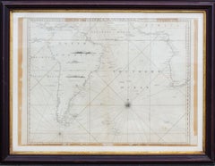
Antique Sea Chart Java Indonesia – Mannevillette Neptune Oriental 1775 This elegant eighteenth-century sea chart of the island of Java is the work of the renowned French hydrographer Jean-Baptiste d’Après de Mannevillette and was published in his influential maritime atlas Le Neptune Oriental during the mid- to late eighteenth century. The chart, titled “Carte de l’Isle de Java, avec les Isles de Banca, de Billiton, et une Partie de celles de Sumatra et de Bornéo,” represents one of the most important navigational depictions of the Indonesian archipelago produced during the great age of European maritime exploration and trade. Mannevillette was one of the most respected navigational cartographers of the eighteenth century. A captain with the French East India Company, he spent decades gathering navigational observations from sailors and explorers navigating the waters of the Indian Ocean and Southeast Asia. His atlas Le Neptune Oriental, first published in 1745 and expanded in later editions, became an essential reference for European navigators operating in Asian waters and significantly improved the accuracy of maritime charts used by commercial and naval fleets. This chart focuses on the northern and southern coasts of Java, one of the most strategically important islands in Southeast Asia due to its position along major trade routes connecting India, China, and the Spice Islands. The map also includes the nearby islands of Banca (Bangka) and Billiton (Belitung), together with portions of Sumatra and the southern coast of Borneo. These surrounding islands played a crucial role in regional trade and navigation, especially for ships approaching the busy port of Batavia (modern Jakarta), the headquarters of the Dutch East India Company in Asia. The engraving is rich with navigational information essential to eighteenth-century sailors. Depth soundings are carefully recorded along the coastlines and across key maritime approaches. The waters surrounding Java are covered with elaborate rhumb-line networks radiating from multiple compass roses, allowing navigators to plot courses across the sea. Such geometric networks are characteristic of portolan-style navigation charts and create a striking visual pattern across the open ocean. The coastlines are finely engraved with numerous place names marking ports, settlements, rivers, and coastal landmarks. Notable geographic references include the eastern and northern shores of Java, the Strait of Batavia near Jakarta, and the nearby island of Bali at the eastern edge of the map. The southern coast of Borneo and the eastern coast of Sumatra are also clearly identified, emphasizing the interconnected maritime geography of the Indonesian archipelago. Issued as a copperplate engraving and typically published without color, this chart exemplifies the precision and clarity of French hydrographic cartography during the Enlightenment. Its combination of scientific accuracy and refined engraving makes it both a valuable historical document and a visually striking decorative piece. Today charts from Le Neptune Oriental are highly sought after by collectors of maritime cartography and by those interested in the early European mapping of Indonesia and the East Indies. The strong linear design, combined with the complex web of navigational lines, creates a dramatic composition that works exceptionally well as a large framed wall map. Condition: Good antique condition with age-appropriate toning and light foxing. Original fold line as issued from the atlas. Minor marginal wear consistent with age. Plate mark visible. Strong paper. Framing tip: This sea chart frames beautifully with a wide ivory mat and a dark walnut or black frame, allowing the intricate network of navigational lines to stand out while preserving the elegant simplicity of the engraving. We sell this map unframed. Technique: Copperplate engraving Maker: Jean-Baptiste d’Après de Mannevillette, France, circa 1745–1775 Keywords: Java map, Java sea chart, Indonesia antique map, Batavia Jakarta, Strait of Batavia, Bangka Banca, Billiton Belitung, Sumatra, Borneo, Bali, Indonesian archipelago, Dutch East Indies, Southeast Asia map, Mannevillette map, Le Neptune Oriental, French hydrographic chart, maritime navigation chart, rhumb line sea chart, East Indies sea chart, Indian Ocean navigation, 18th century nautical map, antique Indonesia map, Cracotoa, Krakatau
  • Dimensions:
    Height: 21.19 in (53.8 cm)Width: 29.14 in (74 cm)Depth: 0.01 in (0.2 mm)
  • Materials and Techniques:
  • Period:
  • Date of Manufacture:
    1775
  • Condition:
    Good antique condition with age-appropriate toning and light foxing. Original fold line as issued from the atlas. Minor marginal wear consistent with age. Plate mark visible.
  • Seller Location:
    Langweer, NL
  • Reference Number:
    Seller: BG-142241stDibs: LU3054349096572

More From This Seller

View All
Antique Sea Chart of the Coast of Sumatra, Indonesia, circa 1775

Antique Sea Chart of the Coast of Sumatra, Indonesia, circa 1775

Located in Langweer, NL

Antique map titled 'Carte de la Côte Occidentale de l'Isle Sumatra'. Sea chart of the part of the south-western coast of Sumatra with the Nassau (Nias) and Fortune isles. Artists ...

Category

Antique 18th Century Maps

Materials

Paper

Rare Old English Sea Chart of Part of Indonesia with Java, Madura and Bali, 1711

Rare Old English Sea Chart of Part of Indonesia with Java, Madura and Bali, 1711

Located in Langweer, NL

Antique map titled 'A Large Draught of the East End of Java and Madura shewing the Streights of Bally.' Rare early example of this working English Sea Chart of part of Indonesia ...

Category

Antique 1710s British Maps

Materials

Paper

Antique Sea Chart by J. B. d'Apres de Mannevillette, Sumatra, 1780

Antique Sea Chart by J. B. d'Apres de Mannevillette, Sumatra, 1780

Located in Langweer, NL

Antique map titled 'Carte pour aller du Détroit de la Sonde ou de Batavia, au Détroit de Banca'. This uncommon sea chart shows northern Java and eastern Sumatra along with an inset of the small islands in the Detroit Sound. The handsome chart provides detailed navigational information, including the route of Julien Crozet in April 1772, who led a French expedition to the South Pacific after the voyage's commander, Marion De Fresne, and 26 crew members were killed (and allegedly eaten) by a Maori tribe in the Bay of Islands off the coast of New Zealand. With title upper left corner and small inset map of the small isles nearby the south-eastern coast of Sumatra. J. B. d'Apres de Mannevillette, from his atlas "Neptune orientale". French sailor...

Category

Antique Late 18th Century French Maps

Materials

Paper

Original Antique Sea Chart of the Coastline from England to Gibraltar, ca.1700

Original Antique Sea Chart of the Coastline from England to Gibraltar, ca.1700

Located in Langweer, NL

Antique map titled 'A Chart of the Sea-Coast from England to the Streights.' Original antique map showing the European coastline from the South of England (and North of France) to ...

Category

Antique Early 1700s Maps

Materials

Paper

Sea Chart of Part of the Southwestern Coast of Sumatra & Nias, Indonesia, C1775

Sea Chart of Part of the Southwestern Coast of Sumatra & Nias, Indonesia, C1775

Located in Langweer, NL

Antique map titled 'Carte de la Côte Occidentale de l'Isle Sumatra'. Sea chart of the part of the south-western coast of Sumatra with the Nassau (Nias) and Fortune isles. Artists ...

Category

Antique 1770s Maps

Materials

Paper

You May Also Like

West Coast of Africa, Guinea & Sierra Leone: An 18th Century Map by Bellin

West Coast of Africa, Guinea & Sierra Leone: An 18th Century Map by Bellin

By Jacques-Nicolas Bellin

Located in Alamo, CA

Jacques Bellin's copper-plate map entitled "Partie de la Coste de Guinee Dupuis la Riviere de Sierra Leona Jusquau Cap das Palmas", depicting the coast of Guinea and Sierra Leone in ...

Category

Antique Mid-18th Century French Maps

Materials

Paper

Plymouth, England: A Hand-Colored 17th Century Sea Chart by Captain Collins

Plymouth, England: A Hand-Colored 17th Century Sea Chart by Captain Collins

By Captain Greenvile Collins

Located in Alamo, CA

This hand-colored sea chart of the area around Plymouth, England from "Great Britain's Coasting Pilot. Being a New and Exact Survey of the Sea-Coast of England", first published in 1...

Category

Antique Late 17th Century English Maps

Materials

Paper

Johannes van Keulen Hand-Colored Nautical Chart of Portugal, circa 1690

Johannes van Keulen Hand-Colored Nautical Chart of Portugal, circa 1690

Located in Marinha Grande, PT

Johannes van Keulen (1654–1715) Nieuwe Paskaart van de Kust van Portugal Amsterdam, late 17th century, circa 1690 Hand-colored copper engraving on paper. Exceptional late 17th-centu...

Category

Antique 17th Century Dutch Baroque Maps

Materials

Paper